Munros Tables SMC Glen Coe & Glen Etive - OS Explorer Map

Glencoe 


 Beinn Maol Chaluim
The High Mountains of Britain & Ireland Rambler's Guide: Ben Nevis and Glen Coe


Photographs of an ascent of the Corbett Beinn Maol Chaluim

 in Glen Etive

and neighbouring Peaks


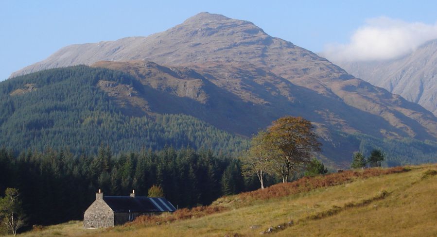
Beinn Maol Chaluim in Glen Etive off Glencoe

Beinn Maol Chaluim ( 907m, 2975ft )

- a Corbett in Glen Etive off 
Glencoe

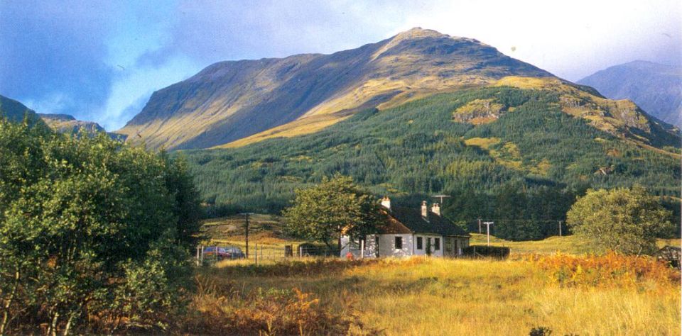
Beinn Maol Chaluim in Glen Etive off Glencoe

Beinn Maol Chaluim ( 907m, 2975ft )

- a Corbett in Glen Etive off 
Glencoe


Loch Etive in Glen Etive

Beinn Maol Chaluim in Glen Etive


Stob Dubh in Glen Etive on ascent of Beinn Maol Chaluim

Stob Dubh ( 2897ft, 883m ) in Glen Etive
 
on ascent of Beinn Maol Chaluim


Ben Starav in Glen Etive on ascent of Beinn Maol Chaluim

Ben Starav ( 1,078m, 3,537ft ) in Glen Etive

on ascent of Beinn Maol Chaluim


Stob na Broige on Buachaille Etive Mor and Clach Leathad ridge on ascent of Beinn Maol Chaluim

Stob na Broige on Buachaille Etive Mor

and Clach Leathad ridge

 on ascent of Beinn Maol Chaluim


Beinn Fhionnlaidh ( 3145ft ) from Beinn Maol Chaluim

Beinn Fhionnlaidh ( 3145ft )

from Beinn Maol Chaluim


Summit Ridge of Beinn Maol Chaluim

Summit Ridge of Beinn Maol Chaluim


Sgor na h-Ulaidh ( 3258ft ) from Beinn Maol Chaluim

Sgor na h-Ulaidh ( 3258ft )

from Beinn Maol Chaluim


Loch Etive and Beinn Trilleachan from summit of Beinn Maol Chaluim

Loch Etive and Beinn Trilleachan

from summit of Beinn Maol Chaluim


Loch Etive and Beinn Trilleachan from summit of Beinn Maol Chaluim

Beinn Maol Chaluim

from Beinn Mhic Chasgaig


Stob Coire Sgreamhach from Beinn Maol Chaluim

Stob Coire Sgreamhach

from Beinn Maol Chaluim


SW Ridge and Face of Bidean nam Bian from summit of Beinn Maol Chaluim

Beinn Maol Chaluim

from Stob Coire Sgreamhach


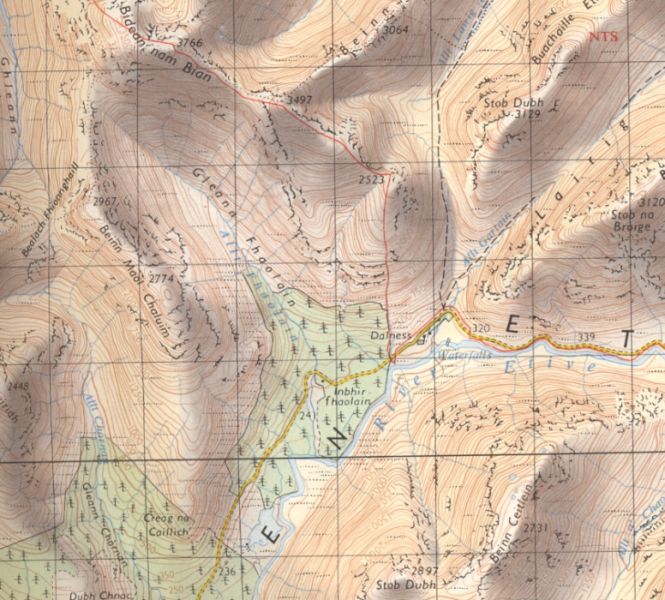
Map of Beinn Maol Chaluim in Glen Etive

Map of Beinn Maol Chaluim in Glen Etive


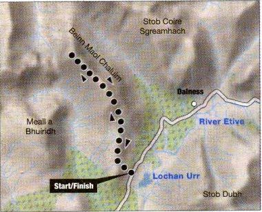
Route Map of Beinn Maol Chaluim in Glen Etive

Route Map of Beinn Maol Chaluim
 
in Glen Etive


BEINN MAOL CHALUIM - ROUTE DESCRIPTION:

Location: Highland
Map: OS Landranger 41 and 50
Distance: 5 miles ( 9km )
Time: 5-6 hours
Terrain: Moderate hill walk


Hidden in a cleft of mountainous land between Glen Coe and Glen Etive, the corbett of Beinn Maol Chaluim ( 2957ft /907m ) does not attract many walkers.
Its proximity to the munros of Glen Coe tends to keep it free of numbers and those who do take the single-tracked road down Glen Etive are
usually intent on bagging the impressive Ben Starav.
Cars can be parked just past Inbhir-fhaolain opposite the waters of Lochan Urr.
Climb the lower slopes of Creag na Caillich to reach Beinn Maol Chaluim’s southern ridge.
The twin Buachailles look magnificent and behind the steep slopes of Stob Dubh fell into the glen in one scree-scarred curtain.
Once you reach the broad south ridge of Beinn Maol Chaluirn only a steep, short and sharp climb separates you from the magnificent high-level
ridge that leads to the summit. Although steep, it’s straightforward until you reach the top of it. There, the summit ridge is protected by a long wall of
vertical red porphyry. You can avoid these crags by traversing right for some distance but there are one or two breaches in the wall where even non-scramblers
can clamber through. Beyond it some minor tops leads to the summit ridge itself.
Beyond loom Stob Coire
Sgreamhach and its connecting ridge to Bidean nam Bean.
Return to Glen Etive admiring on the descent some of the finest views to be seen in this magnificen part of the Scottish highlands.


Route:

Leave the road and climb steep, grassy slopes W of the forest plantation.
Pass rocky outcrops on left to reach S ridge of Beinn Maol Chaluim.
Continue N on ridge and climb to where some crags appear to bar further progress.
Scramble over the crags or avoid by traversing to the right.
Cross a couple of subsidiary tops betore you reach the summit ridge.
Follow to the Summit, which lies at the N end of the ridge.
Return the same way.
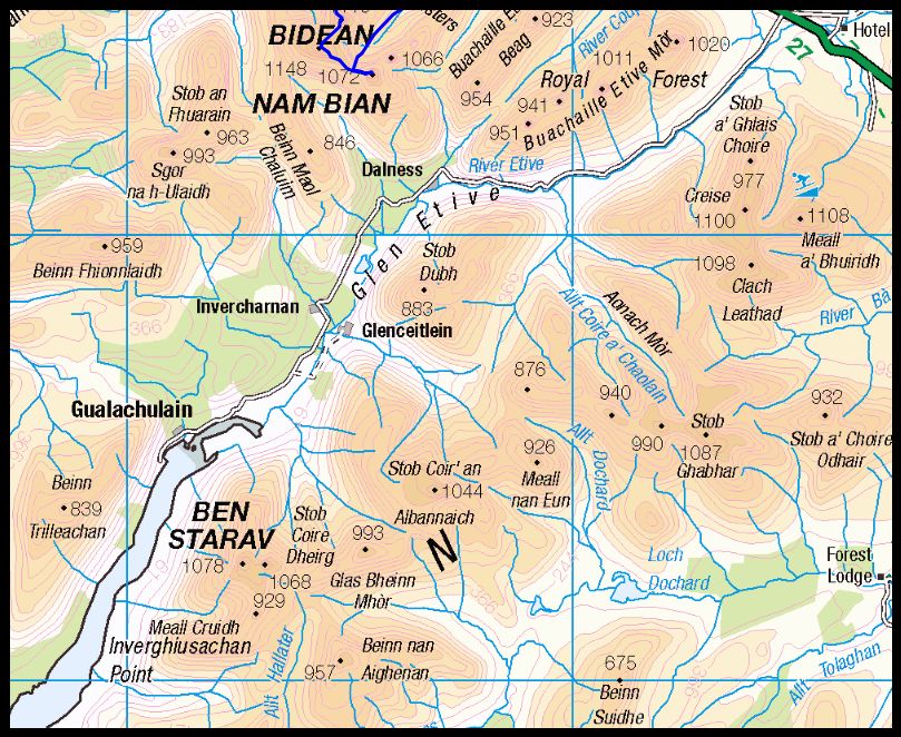


Map of Glen Etive

Map of Glen Etive


Beinn Maol Chaluim Gallery Photo Gallery  :: Glencoe Photo Gallery Photo Gallery
<< Back :: Scottish Peaks Index :: Next >>


Scotland Index :: Scottish Peaks :: Scotland Walks

Glencoe | Knoydart | Isle of Skye | Isle of Arran | The West Highland Way

The Eastern Highlands | The Central Highlands | The Southern Highlands | The NW Highlands


Adventure Travel : Worldwide Mountaineering : Site Index

fb icon  google+ icon Linkedin icon  twitter


Guide Books & Maps - Scotland:-


Torridon - Ben Eighe & Liathach - OS Explorer MapLandranger Map 0024: Raasay, Applecross & Loch Torridon & Plockton


The Munros Map Torridon Map Kintail, Glen Shiel - Map Torridon - Beinn Eighe & Liathach An Teallach & Slioch - OS Explorer Map Applecross & Loch Torridon - OS Landranger Map Gairloch, Ullapool & Loch Maree OS Map Western Scotland & the Western Isles OS Road Map Northern Scotland OS Road MapSouthern Scotland OS Road Map


Ben Nevis & Glencoe - 100 Walks in Lochaber  Ben Nevis & Glencoe

The High Mountains of Britain & Ireland  Munros Tables SMC  The Munros - Scotland's Highest Mountains  Scotland - Lonely Planet  NW Highlands - SMC Guide  Exploring the Far NW of Scotland  Guide to Walks in NW Highlands

Munros & Corbetts Chart Call of the Corbetts Wilderness Walks 2 - Video  Munros Tables SMC  The Munros - Scotland's Highest Mountains  Scotland - Lonely Planet

Walking in Scotland - Lonely Planet Mountain: Exploring Britain's High Places  National 3 Peaks Walk Scottish Highlands Hillwalking Guide The Scottish Islands Bouldering in Scotland

Pathfinder Guide: Skye and NW Highlands WalksNW Highlands SMC Torridon: A Walkers Guide Torridon - Life & Wildlife in the Scottish Highlands The Munros: Scottish Mountaineering Club Scotland's Far NorthNorthern Highlands Northern Highlands, Volume 1 - SMC Northern Highlands, Volume 2 - SMC

Highland Outcrops Scottish Winter ClimbsWest Highlands 50 Walks in the Scottish Highlands & Islands Scotland's Highlands & Islands - Lonley Planet Scottish Highlands & Islands - Rough Guide The Munros and Tops Call of the Corbetts The Corbetts - SMC

Ben Nevis - Scotland's Highest Mountain Ben Nevis: Rock & Ice ClimbsThe High Mountains of Britain and Ireland Rambler's Guide: Ben Nevis and Glen CoeWinter Climbs: Ben Nevis and Glencoe Ben Nevis Rock & Ice Climbs Great Snow & Ice Climbs of the British IslesPathfinder Guide: Fort William and Glen Coe Walks Scrambles in Lochaber

Rock Climbing in Scotland Classic Mountain Scrambles in Scotland Scotland - Lonely PlanetScotland's Highlands & Islands - Lonley Planet Scotland's Highlands & Islands - Rough Guide Highlands & Islands of Scotland - Hidden Places Scotlands 100 Best WalksCentral Highlands: Six Long Distance Walks Rough Guide Scotland

Scottish Highlands & Islands - Rough Guide The Munros - Scotland's highest mountains My Scotland by Hamish MacInnes Scottish Mountains - 50 Classic RoutesThe CuillinsScottish Mountains - 100 Best Routes

Munro Almanac The Munros Map The Munros: Scottish Mountaineering Club The Isle of Skye The Isle of Arran Wilderness Walks Ski Mountaineering in Scotland Classic Walks in Britain & Ireland

More Wilderness Walks 50 Best Routes on Skye and Raasay Skye - W.A.PoucherMagic of the Munros Mountaineering in Scotland and Undiscovered Scotland by W.H.MurrayA Long Walk on the Isle of Skye

Classic Climbs - Central & Southern Highlands The Isle of Arran Lonely Planet, Walking in ScotlandPathfinder Guide: Skye and NW Highlands Walks50 Best Routes on Skye and Raasay - Chris Townsend 100 Best Routes on Scottish Mountains Scrambles in Skye Mountain Days & Bothy Nights

Walking in the Hebrides Torridon: A Walkers Guide Ski Touring in ScotlandRough Guide: Scotland A Mountaineer's Tale - W.H.MurrayDougal Haston: Philosophy of RiskOne Man's Mountains - Tom Patey Big Walks of Great Britain

The Glens of Rannoch Cairngorm Glens Glens of Trossach Knoydart to Morven Scottish Glens: The Atholl GlensSouthern Highlands - Map Northern Highlands The Munro Show 1 & 2 - Muriel Gray

The Cairngorms Cairngorms Walks Cairngorm - Map Walks in the Cairngorms Lochnagar & Glenshee - Map The Cairngorms of Scotland Cairngorms - Mountain Bike GuideWinter Climbs in the Caingorms

West Highland Way: Official GuideWest Highland Way: Rucksac ReadersWest Highland Way: TrailblazerThe West Highland WayWest Highland Way: Footprint MapWest Highland Way - Map West Highland Way - Map 100 Hillwalks around Glasgow

50 Walks in Glasgow & SW Scotland 50 Walks in the Scottish Highlands & Islands 50 Walks in Edinburgh & Eastern Scotland 100 Walks in ScotlandVisit Scotland - Touring Guide Scotland: Where to Stay - Hotels & Guest Houses Scotland: Where to Stay - Bed & Breakfast Walking the Munros Vol 2: Northern Highlands & CairngormsWalking the Munros Vol 1: Southern, Central & Western Highlands

Hillwalker: The MunrosHillwalker: The CorbettsWeather for Hillwakers & Climbers Mountain Weather Guide to the Weather Weather: Collins Gem Hillwalking Handbook for Mountain Leaders First Aid on Mountains

All Mountain Skier Off Piste World's most significant ClimbsMountain Travellers HandbookMountaineering: The Freedom of the HillsHillwalkers Guide to Mountaineering 200 Challenging Walks in Britain & Ireland

Ice & Mixed Climbing How to Ice Climb Complete Climbers Handbook Mountain Skills Training Handbook Autumn Road to the IslesDiscovering Scotland - Atlas & Guide Scotland Travel Guide Lonely Planet Scotland - The Wild Places - Colin Prior


Google Analytics


Google Analytics

extremetracking

 eXTReMe Tracker


extremetracking

Sitelock caingram.com
SiteLock
Sitelock
Sitelock caingram.info
SiteLock
Sitelock