Glasgow Guide Forth and Clyde Canal

City of Glasgow

Forth & Clyde Canal

Maryhill to Temple
Glasgow - A Portrait Forth & Clyde Canal

Photographs of the Forth and Clyde Canal

 through Glasgow from Maryhill

 to Temple at Anniesland

Forth and Clyde Canal in Maryhill in Glasgow

Forth and Clyde Canal

in Maryhill in Glasgow


Lock 21 on Forth and Clyde Canal in Maryhill, Glasgow

Lock 21

on Forth and Clyde Canal

in Maryhill


Basin on Forth and Clyde Canal in Maryhill, Glasgow

Basin on Forth and Clyde Canal

in Maryhill


Basin on Forth and Clyde Canal in Maryhill, Glasgow

Basin on Forth and Clyde Canal

in Maryhill


Kelvin Dock on Forth and Clyde Canal in Maryhill, Glasgow

Kelvin Dock

on Forth and Clyde Canal

in Maryhill


Kelvin Dock on Forth and Clyde Canal in Maryhill, Glasgow

Kelvin Dock

on Forth and Clyde Canal

in Maryhill


Barge on Forth and Clyde Canal in Maryhill, Glasgow

Barge on Forth and Clyde Canal

in Maryhill


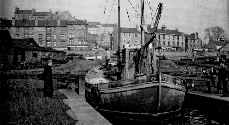
Fishing boat in Forth and Clyde Canal in Maryhill


Aqueduct of the Forth and Clyde Canal across Maryhill Road in Glasgow

Aqueduct of the Forth and Clyde Canal

across Maryhill Road in Glasgow


Forth and Clyde Canal in Maryhill, Glasgow

Maryhill Parish Church

from Forth and Clyde Canal

in Maryhill

Glasgow Churches Gallery Photo Gallery


Gas Works at Anniesland beside the Forth and Clyde Canal

Gas Works at Anniesland

beside the Forth and Clyde Canal


Gas Works above the Forth & Clyde Canal from Maryhill to Anniesland

Gas Works above the Forth & Clyde Canal

from Maryhill to Anniesland

Constructed for the Corporation of Glasgow
which was the second largest gasworks in Britain.

 Gas holder number four, 136ft high,
was built in 1893
and was the third largest in the world.

 Its neighbour, 146ft tall,
was built seven years later.

Accorded category "B" listed buildings status.


Lock 27 on the Forth & Clyde Canal at Anniesland

Lock 27

on the Forth & Clyde Canal

 at Anniesland


Lock 27 on the Forth & Clyde Canal at Anniesland

Lock 27

on the Forth & Clyde Canal

 at Anniesland


Bridge over the Forth & Clyde Canal at Anniesland

Bridge over the Forth & Clyde Canal

at Anniesland


Swans on the Forth and Clyde Canal

Swans on the Forth and Clyde Canal

at Temple, Anniesland


Swan on the Forth and Clyde Canal

Swan on the Forth and Clyde Canal

at Temple, Anniesland


Lock 27 at Temple on The Forth and Clyde Canal

Lock 27 at Temple

on the Forth and Clyde Canal


Barge on The Forth and Clyde Canal at Temple

Barge on the Forth and Clyde Canal

at Temple, Anniesland


The Forth and Clyde Canal

The Forth and Clyde Canal


 MARYHILL - WALK NARRATIVE:


Maryhill, like Venice, owes its existence to canals. It is said of Glasgow that “the city made the Clyde and the Clyde made the city, but in contradistinction to this, it was the Forth and Clyde Canal, and its branch to Port Dundas, that made the burgh of Maryhill. The canal snaked through the area from the 1790s and became the artery of Scotland’s Industrial Revolution, carrying raw materials inwards from, and manufactured
goods outwards to, the world.
Industry grew alongside the canal in Maryhill, benefitting from cheap transport costs; but once more in contrast to Glasgow - Where most industrial enterprises were on a massive scale — Maryhill’s industries were small scale, restricted by the lack of land around the canal, and they were also extremely varied. Govan was ships, Springburn locomotives and Possil iron, but Maryhill had a large variety of industries; textiles, brewing,
glassworks, chemical works, paper mills and many more, which gave rise to one of Glasgow’ s most glorious and little-known artworks, ( see below ).
Maryhill grew over 150 years from scattered settlements to a population which peaked at 40,000 after World War Two. Since then it has lost nearly all its industry and a good chunk of its population, which has stabilised at about 25,000. But, despite plans over the years to infill the waterway,
Maryhill has not lost its canal, which was restored as a Millennium Project and is now a flourishing recreational facility. Nor has it lost much of its fine built environment, unsuspected by those who drive up Maryhill Road without stopping.
To experience this, walking is best, and here follows an amble round central Maryhill.
1. Take the train from Queen Street to Maryhill Station and walk south down Maryhill Road till you reach the former Kelvin Dock. This landscaped area was formerly Swann’s boat building and repair yard where were constructed canal barges and Clyde Putters, from the 1850s till the early
1960s. Landing craft for the D-Day invasions of Normandy were built here. The artist Ioan Eardley painted
camouflage on these. Cross the lock gates to gain the canal walkway, the former towpath for the barges.
2. Make a right turn to quickly reach the Kelvin Aqueduct, a wonder of industrial engineering and listed as an Ancient Historical Monument.
The aqueduct strides proudly across the River Kelvin which runs beneath its four grand arches. Designed by the engineer Robert Whitworth, and built between 1787 and 1790 it cost £8,500, almost bankrupting the canal company, but completing the east-west waterway link.
Retrace your steps and follow the canal southwards, past some delightful new “Amsterdam” ( well, it is a canal ) style social housing, then cross over and above the Maryhill Road by a smaller aqueduct.
3. We are new in the former heart of industrial Maryhill, though little of this remains. One factory which still stands is the brick building,
renovated, on the right. This was Clarkson’s Engine Works, where small and medium-size steam engines were made for ships and factories. Now an events space for weddings and parties. Further on, at Stockingfield Junction, the Forth and Clyde canal winds its way to Falkirk and further; the block of new white flats you see that-aways was built on the site of the former Milanda Bakery. We continue however down the Glasgow branch of the canal. On your right are some warehouses and the ground of Maryhill Juniors FC. Formerly many industries were located here;
a brewery, a textile works and, most notably, the Maryhill Iron Works. Andy Scott, the sculptor of The Kelpies, had his workplace in this area.
4. In summer this part of the canal is awash with blue and purple orchids on the bank, yellow irises at the canal edge and white water lilies on the water; across the canal lies some wild land, where it is possible to see foxes, deer, and very occasionally, a badger.
Bird life exhibits to us heron, coot, grebe, goosander and more. Whaur’s Yer Canal du Midi, Noo? Just before Ruchill Street, and the underpass below it, on the left is a brick building which some might recall as the Bryant and May match, factory, closed in the 1980s, and now offices and workspaces. Under and beyond the underpass lies the stunning collection of Mondrian flats, created in the 2000s, on what was the site of largest industrial undertaking in Maryhill, Maclellan’s Rubber Works; this factory closed only 15 years ago.
5. Step back,100 yards or so now, for we are leaving the canal, and heading down Ruchill Street towards Maryhill Road. On Ruchill Street is Ruchill Parish Church, a fairly undistinguished building, but next door is a real gem, Rennie Mackintosh’s Ruchill Church Halls, built in 1899 in his Art Nouveau Scottish vernacular fusion, with a turreted caretaker’s house in the courtyard. A-Listed, this is still a functioning religious building with many associated social activities, and is almost intact inside from its construction. Sometimes the hall is open and visitors are welcome. On one of  my visits I was suggesting to the caretaker that, given the value of the contents, security arrangements were -a bit  The response? ‘Aye, then, son, if anything goes missing’, We’ll know it was you.” ( www.ruchillparish.org.uk ).
5. Moving back north up Maryhill Road, opposite the Tesco superstore stands Frampton’s Night Club, formerly the Maryhill Trades Union Centre but originally the Soldiers’ Home, a social club for Maryhill Barracks where those on leave could stay with their families. A charming wee toy of a building with battlements and other military features. Evenings here were reputed to be lively affairs before lockdown.
A little further on up the road, but across on the other ( left ) side of the street, is the wall of the former Maryhill Barracks, closed in the 19605 and demolished. At the entrance marked by iron stanchions embellished with the initials VR, is located the former barracks gatehouse.
Local legend has it that Rudolf Hess was briefly detailed here on his ill-fated peace mission in 1941.
Behind the walls lies the Wyndford housing estate, which won a Saltire Award when it was constructed, and was recently completely renovated.
7. Yet further north we come to Gairbraid Avenue, back along which in days gone by lay Gairbraid House, where dwelt Mary Hill the wife of the estate owner, who gave her name to the town. Now on the corner stands the refurbished and reopened B-Listed Maryhill Burgh Halls by architect Duncan MacNaughtan, in French Renaissance Style. The halls date from 1878 and served the burgh till annexation by Glasgow in 1891.
Their crowning glory are a set of 20 stained glass panels by Stephen Adam depicting the industries of the burgh in the High Victorian period. Restored and replaced in the halls ( in rotations of 10 ) the panels are one of the finest works of art of the gilded age of Glasgow’ s cultural life.
They can be viewed on the website of the halls, but for their full impact go and see them once the halls reopen after Covid.  ( www.maryhillburghhalls.org. uk )
8. Before you pass under the short aqueduct over Maryhill Road that you walked across awhile previously, notice on the right Maryhill Library,  one of six designed for Glasgow in 1905 by the architect R. Rhind, with its sculpted figures of a pedagogic matriarch and attendant children high on the frontage. The entire collection of Rhind’s libraries are A-Listed.
Once under the aqueduct you pull up the brae to find yourself on the east side of the canal, with the White Hoose as it is locally known, soon appearing on your left beside a berthage for canal craft. This building is probably the oldest in Maryhill and dates from the time of the canal construction, and was at once a hostelry, a stables and a hotel for passengers on the canal and for the bargemen and their beasts. It was open 24 hours a day, as barges, called “hoolets” ( owlets ) carried goods and passengers on the canal at all times. Dilapidated for many years, after
various uses, it is now a cycle repair and hire base for trips on the towpath and beyond. The White House lies on the Maryhill locks complex at Kelvin Dock, where our walk began, and from it is a short tramp further up Maryhill Road and back to Maryhill Station.Stained glass wonders, a Mackintosh masterpiece, Ancient Historical Monuments and a canal walk to die for, if that wasn’t your view of Maryhill, it will be after this walk. lan R Mitchell is the author of A Glasgow Mosaic; Cultural icons of the City ( 2072 ) which includes an extended essay of Stephen Adam ’s Maryhill stained glass panels.


Forth & Clyde Canal Gallery
Photo Gallery

<< Back : Glasgow Index : Next >>


Glasgow Walks :: Scotland Index

Glencoe | Ben Nevis | Knoydart | Isle of Skye | Isle of Arran | The West Highland Way

The Eastern Highlands | The Central Highlands | The Southern Highlands | The NW Highlands


Adventure Travel : Worldwide Mountaineering : Site Index

fb icon  google+ icon Linkedin icon  twitter


Guide Books & Maps - Scotland:-


Western Scotland & the Western Isles OS Road Map Northern Scotland OS Road MapSouthern Scotland OS Road MapGlasgow Popular Hills - Map


Forth & Clyde Canal  Forth and Clyde Canal Exploring Edinburgh - Glasgow Canals 

Glasgow - A Portrait Wee Book of Glasgow  Glasgow from the Air  Glasgow - No Mean City  Lost Glasgow  Glasgow - The Real Gorbals Story    

Glasgow Visitor Guide - Colin Baxter Itchy Insider's Guide to Glasgow Glasgow Footprint Pocket Guide Glasgow Insight Pocket Guide Glasgow Guide Pub Companion Glasgow Scotland's Highlands & Islands - Rough Guide Scotland - Rough Guide

Glasgow Insight Pocket GuideCollins Street Map of GlasgowGlasgow: Then & NowThey belonged to Glasgow Phillips Street Atlas of Glasgow & West Central Scotland Glasgow: The Photographic Atlas100 Hillwalks around Glasgow 50 Walks in Glasgow & SW Scotland

Visit Scotland - Touring Guide Scotland: Where to Stay - Hotels & Guest Houses Scotland: Where to Stay - Bed & Breakfast Rough Guide ScotlandScottish Highlands & Islands - Rough Guide Scotland - Lonely PlanetScotland's Highlands & Islands - Lonley Planet Great Glasgow StoriesGlasgow & Surroundings - Insight Guide

West Highland Way: Official GuideWest Highland Way: Rucksac ReadersWest Highland Way: TrailblazerThe West Highland WayWest Highland Way: Footprint MapWest Highland Way - Map West Highland Way - Map West Highland Way Wet Highland Way - Official Guide

Munro Almanac The High Mountains of Britain and Ireland The Munros: Scottish Mountaineering Club The Isle of Skye The Isle of Arran Wilderness Walks Ski Mountaineering in Scotland

More Wilderness Walks 50 Best Routes on Skye and Raasay Skye - W.A.PoucherMagic of the Munros Mountaineering in Scotland and Undiscovered Scotland by W.H.MurrayA Long Walk on the Isle of Skye

Classic Climbs - Central & Southern Highlands The Isle of Arran Lonely Planet, Walking in ScotlandPathfinder Guide: Skye and NW Highlands WalksPathfinder Guide: Fort William and Glen Coe Walks Rambler's Guide: Ben Nevis and Glen Coe50 Best Routes on Skye and Raasay - Chris Townsend


Google Analytics


Google Analytics 

extremetracking
 eXTReMe Tracker


extremetracking
Sitelock caingram.com
SiteLock
Sitelock
Sitelock caingram.info
SiteLock
Sitelock