
Encamped beneath towering pine trees amid the sparkling, springtime beauty of the snow-bound Rocky Mountains, I contemplated the tranquil stream flowing sedately between green meadows. It was hard to believe that only a few hundred miles down river it was to gouge out the greatest gorge in the world - the Grand Canyon - one of the seven wonders of the world.
Colorado River
in Rocky
Mountain NP |
|
Starting in Denver, the "mile-high city", I was to follow the course of the Colorado River from its source in the Rocky Mountain National Park through some astonishing, sculptured sandstone in Arches and Canyonlands National Parks and the spectacular Monument Valley of Western movie fame to finish with a descent from rim to river of the Grand Canyon.
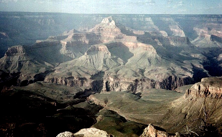
A long drive over straight roads through the luminescent landscape of the "Painted Desert" to the accompaniment of Navajo Indian music on the radio - the only station receivable - brought me into Arizona and the forested rim of the Grand Canyon. Walking along the trail on the southern edge I gazed in awe at the multiplicity of castellated ridges, like the gigantic battlements of some fairy-tale citadel, rising from the depths of the enormous chasm.
 The Grand Canyon from the South Rim |
Occasional glimpses could be seen of the brown ribbon of the Colorado River in the valley floor far below. Over a period of some 1.2 million years it had carved its way through 11 different rock strata to expose the greatest cross-section of geological time anywhere in the world. In the evening the colours and contrast changed dramatically as the final rays of the setting sun highlighted Wotan's Throne - a prominent landmark on the far side of the canyon.
 Wotan's Throne in the Grand Canyon |
At sunrise next morning, with some trepidation, I started down the relentless zig-zags of the Bright Angel Trail. It was a long way to the river and the uphill return was of some concern - not so much the vertical distance of about 4,500 feet but more the expected high temperatures in the lower depths of the canyon - there were dire warnings posted of deaths from dehydration and heat exhaustion.
 Zig_zags on the Bright Angels Trail leading down into the Grand Canyon |
Most people take two days; descending on one day, spending the night in the campsite in the valley floor then re-ascending the following day. However places are limited and require a permit for which there had been a huge queue. I was therefore tackling the round trip in one day hoping my recent forays into the desert in Arches and Canyonlands would have helped with acclimatization.
 Claret Cup Cactii at the foot of the Grand Canyon |
After only 15 minutes the top of the sheer limestone and rust-red sandstone walls loomed high overhead. The steep, narrow track was deserted but there was an overpowering stench left by the mules that make daily trips to the outlook at Plateau Point about halfway down the canyon.
Some 3000 feet beneath the rim the trail levelled out onto the plateau and the lush greenery and tall cottonwood trees surrounding the springs at Indian Gardens. A long traverse around the scree slopes of another of the many side-canyons led down into a steep, narrow defile constraining the rushing waters of the Bright Angel Creek.
I began to meet hikers coming up from their overnight stay in the valley floor. My ski-sticks ( now termed trekking poles ) attracted comment; "You won't find any snow down there", "If you're looking for snow you're going the wrong way".
Suddenly there was a great roaring and the defile opened out onto the sandy banks of the surprisingly-broad, swiftly-flowing, muddy-brown waters of the Colorado River. It was then only a short walk through a desert zone of small sand-dunes, covered in red-and-yellow, flowering cacti, beneath high, enclosing, granite walls to the Silver Suspension Bridge.
 The Silver Bridge across the Colorado River at the foot of the Grand Canyon |
On the far side a small grove of trees provided very welcome shade and a tap at the pump station replenished my water-bottle. Although only 10 o'clock the temperature had been rising steadily during the descent and it was now like an oven in the still confines of the gorge.
 Colorado River at the foot of the Grand Canyon |
After only a short respite I headed back for the top. A long, leisurely trudge reached the pleasant oasis at Indian Gardens for an extended break in the cool of the cottonwoods but the canyon rim looked impossibly far and inaccessible at the top of sheer cliffs. Only from the innermost recess of the side-canyon did the trail begin its tortuous and unrelenting climb to the top.
Grinding up the well-graded zig-zags in full exposure to the remorseless sun I began to catch up with and overtake some of the hikers I had met on my way down. There were no comments now on my ski-sticks - only envious glances. At 3 o'clock in the afternoon I regained the rim - in the words of the souvenir T-shirts - I had "Done The Canyon".
The descent into the depths of the chasm had been the highlight of my tour although less than 5% of all visitors venture onto the network of trails threading the Grand Canyon.
( The Commentator, The (Glasgow) HERALD Saturday 12th December 1998 )
Colorado Circuit | Great Sand Dunes | Mesa Verde & Garden of the Gods
Colorado Rockies | Colorado National Monument | Canyonlands, Arches & Monument Valley | The Grand Canyon
Mt. Whitney | Sequoia & Yosemite | Death Valley