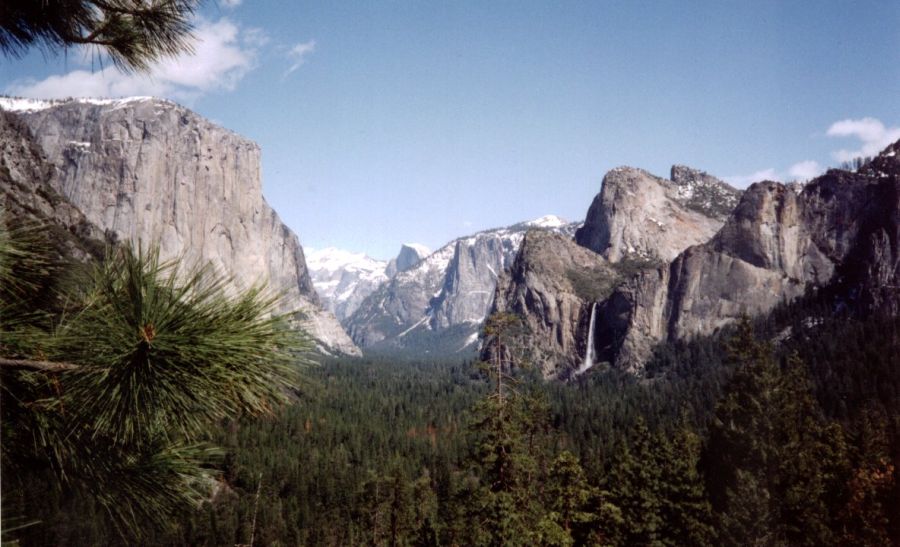

Entering Yosemite - "The Incomparable Valley" - the view ahead is simply stunning - towering rock walls line the sides of the narrow, forested, U-shaped canyon and tall waterfalls cascade from the heights. In the distance looms the eye-catching and aptly-named Half Dome - a gigantic, granite monolith sculptured by aeons of glacier erosion.
 YosemiteValley
|
|
At the picturesque Upper Pines campsite I pitched my tent amid the fragrant forest directly beneath majestic cliffs. Although it is essential to make bookings many months in advance for the peak summer period vacant sites were plentiful for my springtime visit to this popular National Park set aside in 1890 to preserve a set of wildlands stretching along the Sierra Nevada mountains of California. The writings and efforts of Scotsman John Muir rank above all others in the establishment of Yosemite.
On a clear, crisp, morning I set off along the well-graded trail to the Yosemite Falls - the world's third highest with its vertical drop of 2,425 feet. The leaf-carpeted path wound steadily upwards through black-oak woodland before contouring round the steep, craggy hillside to reach the great plume of spray splashing off the huge mound of white-ice at the base of the giant cataract.
 Yosemite
Falls
|
|
To climb higher appeared impossible but the trail continued into a hidden gully where it spiralled upwards in tight zig-zags through the cleft to emerge eventually onto an undulating, snow-covered plateau. Following the banks of a partially-frozen stream I came to the wooden gallery at the top of the waterfall for a sensational vantage point. Directly underfoot, the waters of the stream cascaded over the precipice to crash onto the ice-covered rocks far below.
A higher gallery further along the edge of the cliffs provides a breathtaking, bird's-eye view over the spectacular alpine valley with its Merced River meandering sedately through a mosaic of green meadows and conifer forests of incense cedar, ponderosa pine and Douglas fir. Immediately opposite, Granite Point surmounts seemingly vertical rock walls and can also be reached by a tortuous path from the valley floor or, less sportingly, from a high roadhead.
Beyond the incredible Half Dome, the "King of Yosemite's Granite Domes", extend the serrated peaks and rugged ridges of the Sierra Nevada. An eight-mile trail leads to a chained, climbing route up the eastern ridge to the 8,842 feet summit of Half Dome but is closed during winter and early spring due to avalanche danger.
 Half
Dome
|
|
That night I was disturbed in my tent by noises outside and was surprised and somewhat alarmed to discover a pair of coyotes foraging around the campsite. Thankfully it was none of the black bears that also inhabit the valley and cause thousands of dollars worth of damage each year as well as serious injuries to visitors.
Crossing the Merced River a level trail through the tall pines alongside Tenaya Creek brings one to Mirror Lake where the still, dark waters reflect perfectly the rugged profile of Mt.Watkins rising at the valleyhead. Overhead soars the awesome, perpendicular face of Half Dome - one of America's renowned "Big Walls" - an extreme challenge for the technical climber.
 Mount Watkins from Mirror Lake |
A short distance further up the valley I branched off along the Snow Creek Trail, on the northern flank of the ravine, and climbed through the pine trees to emerge onto open slopes resplendent in colourful, lilac-flowered shrubs. As altitude was gained the full splendour of the Yosemite Valley was increasingly revealed in all its glory. Nearby smooth, polished rock surfaces plunged from the lofty, rounded top of Basket Dome in direct opposition to the immense, vertical wall of Half Dome across the great, glacier-gouged canyon.
 Basket
Dome
|
|
Continuing higher I crossed the snow-line back into dense, coniferous forest before once again gaining the plateau where extensive, untracked snowfields led to an isolated hilltop and a fine outlook. Across the dazzling, tree-studded slopes soared the summits of Mt.Watkins and Basket Dome with Half Dome in dramatic silhouette from the afternoon sun.
 Half
Dome
|
|
Before leaving Yosemite I toured the many photo opportunity locations ( identified for visitors in a free leaflet from Kodak available from the National Park Office ) on the circular road round the floor of the main valley to admire the shapely Sentinel Rock, the monumental monolith of El Capitan - another of America's "Big Walls" - and the graceful, twin pinnacles of Cathedral Spires rising from the green, grassy meadows bordering the banks of the tranquil Merced River. Some suggest that the "Incomparable Valley" was in fact designed by Kodak to promote the use of its products.
( The Commentator, The (Glasgow) HERALD Saturday 21st May 1999 )
Wikipedia - Sequoia National Park
Sequoia National Park
Sierra Nevada Mountain Climbing
Travel & Guide Books & Maps
Colorado Circuit | Great Sand Dunes | Mesa Verde & Garden of the Gods
Colorado Rockies | Colorado National Monument | Canyonlands, Arches & Monument Valley | The Grand Canyon
Mt. Whitney | Sequoia & Yosemite | Death Valley