West Highland Way: Trailblazer Ochils and Campsie Fells

 Bearsden & District

Balfron Circuit

West Highland Way - Map West Highland Way: Footprint Map


Photographs of a circular walk starting and finishing in the village of Balfron

 with views of
the Campsie Fells and Fintry Hills

and along the banks of the Endrick Water

Parish Church in Balfron

Parish Church in Balfron

Balfron Village is some 16 miles ( 26km ) to the north of Glasgow
 on the
northern side of the Campsie Fells


The Clachan Oak — the original centre of Balfron

The Clachan Oak — the original centre of Balfron


Donaldson Park off Spoker's Loan in Balfron

Donaldson Park off Spoker's Loan in Balfron


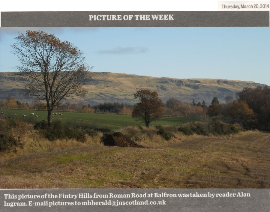
Fintry Hills from Roman Road at Balfron

Fintry Hills from Roman Road


Fintry Hills from Roman Road at Balfron


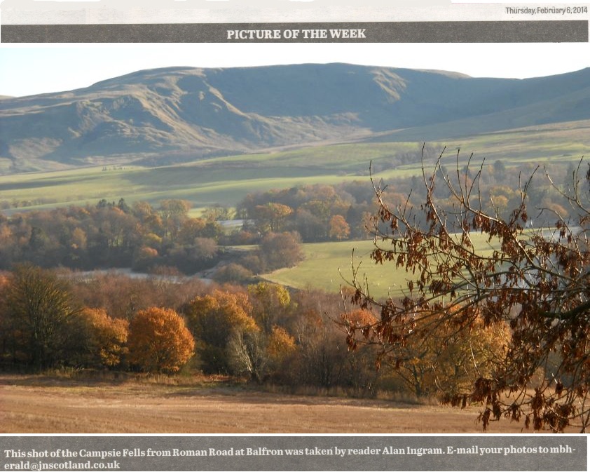
The Campsie Fells from Roman Road at Balfron


White Yett Lodge at start of the public path to Balfron Bowling Green

White Yett Lodge at start of the public path to Balfron Bowling Green.


Public path through White Yett Glen to Balfron Bowling Green

Public path through White Yett Glen to Balfron Bowling Green.


Iron Bridge over the Endrick Water

Iron Bridge over the Endrick Water


Campsie Fells from the Endrick Water


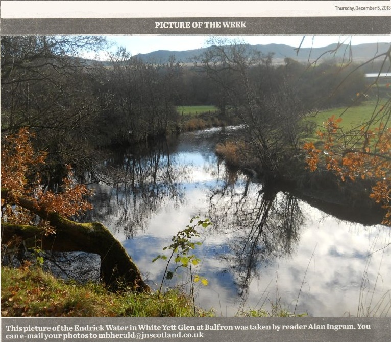
Endrick Water from the public path to Balfron Bowling Green

  Endrick Water from the public path to Balfron Bowling Green


Campsie Fells from Balfron Bowling Green

 Campsie Fells from Balfron Bowling Green


Campsie Fells from Balfron

Campsie Fells from Balfron 


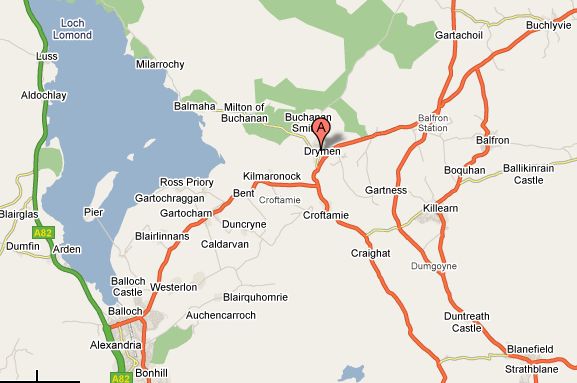
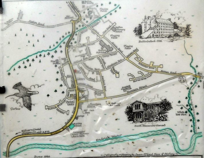
Map of Balfron Area

Map of Balfron Area


Map of Balfron

Map of Balfron

( Note: Click here or on above for large format copy )


Map of Balfron area

Map of Balfron Area


BALFRON CIRCULAR WALK - ROUTE DESCRIPTION:

This walk is circular stroll of about four miles and two hours around the attractive historical village of Balfron.
To get there by car, take the Strathblane Road, A81, from Milngavie to the Glengoyne Distillery, then the A875 through Killearn and on to Balfron.
There is also a bus service direct to Balfron from Glasgow that passes through
Milngavie. Suitable car parking in Balfron is available beside the Co-operative building at the top of Buchanan Street.
On leaving the car park onto Buchanan Street, pause and look downhill to admire the impressive view which extends beyond the village to the Campsie Fells and Dumgoyne.
The walk then takes the opposite direction and turns left to pass the shops and the Bank of Scotland on the right.
It rounds a bend on the road to The Clachan — the original centre of the village — where the focal point is the Clachan Oak, claimed to be a resting place in the shade for both William Wallace and Rob Roy.
Also of historical interest at the corner of the road is Clachan House dated 1776. The long white building, Orchardlands, to the right was once the village school. Behind the tower shaped war memorial commemorating two world wars is the 1832 stone built parish church in its kirkyard.
The road on the right beyond the church is a parking entrance for the church, golf club and football ground. The walk continues by turning sharp right before the church into Spoker's Loan, one of the street names in Balfron denoting its association with the cotton mills. It passes by the gate on the left to Donaldson Park, a children‘s play area, turns left into Cotton Street, then sharp right into Roman Road to pass Balfron School Campus. On nearing the end of the village, ( take care no pavement ) the
Campsie Fells once again come into view on the right and at the fork junction with Dunmore Street an option route is available.
Continuing straight ahead passes the fortified motte on the left and turning right onto the public path before the White Yett Lodge, signed Bowling Club via Glen is a pleasant wood walk which goes downhill initially and crosses over a bum alongside the Endrick Water.
However after passing through the next signed Public Path gate on the right, the path becomes muddy which is a pity as it can spoil the walk.
It eventually enters a field and emerges at the side of the Scottish Water plant and the bowling club at the bottom of Buchanan Street.
It is considered best to take this route when theweather is a bit dryer or with very good stout walking boots on as it can be slippery.
The alternative route is to turn into Dunmore Street at the fork junction. It is an interesting road to walk along with a row of old fashioned houses on the right. The views on the left over the site of Robert Dunmore’s Ballindalloch Cotton works to the Endrick Water and the
Campsie Fells on a clear day afford some truly beautiful views.
Halfway along the street stands Alexander ‘Greek’ Thomson‘s Old South Manse and at the end before rejoining Buchanan Street is the John McLintock Hall. Both men remembered as having contributed to the wellbeing of the village in their time.
The circular walk is complete with the climb up Buchanan Street to the car park passing the Library and Police Station on the way.


  Endrick Water Gallery Photo Gallery :: Balfron Gallery Photo Gallery :: Campsie Fells Photo Gallery 

<< Back : Bearsden Walks Index :: Next >>


Scotland Index :: Scottish Peaks :: Scotland Walks

Glencoe | Ben Nevis | Knoydart | Isle of Skye | Isle of Arran

The Eastern Highlands | The Central Highlands | The Southern Highlands | The NW Highlands


Adventure Travel : Worldwide Mountaineering : Site Index

fb icon  google+ icon  Linkedin icon  twitter


Guide Books & Maps - Scotland:-


West Highland Way: Footprint MapWest Highland Way - Map West Highland Way - Map Western Scotland & the Western Isles OS Road Map Northern Scotland OS Road MapSouthern Scotland OS Road MapGlasgow Popular Hills - Map


Ochils and Campsie Fells

Glasgow Visitor Guide - Colin Baxter Itchy Insider's Guide to Glasgow Glasgow Footprint Pocket Guide Glasgow Insight Pocket Guide Glasgow Guide Pub Companion Glasgow Scotland's Highlands & Islands - Rough Guide Scotland - Rough Guide

Glasgow Insight Pocket GuideCollins Street Map of GlasgowGlasgow: Then & NowThey belonged to Glasgow Phillips Street Atlas of Glasgow & West Central Scotland Glasgow: The Photographic Atlas100 Hillwalks around Glasgow 50 Walks in Glasgow & SW Scotland

Visit Scotland - Touring Guide Scotland: Where to Stay - Hotels & Guest Houses Scotland: Where to Stay - Bed & Breakfast Rough Guide ScotlandScottish Highlands & Islands - Rough Guide Scotland - Lonely PlanetScotland's Highlands & Islands - Lonley Planet Great Glasgow StoriesGlasgow & Surroundings - Insight Guide

West Highland Way: Official GuideWest Highland Way: Rucksac ReadersWest Highland Way: TrailblazerThe West Highland WayWest Highland Way: Footprint MapWest Highland Way - Map West Highland Way - Map West Highland Way Wet Highland Way - Official Guide

Munro Almanac The High Mountains of Britain and Ireland The Munros: Scottish Mountaineering Club The Isle of Skye The Isle of Arran Wilderness Walks Ski Mountaineering in Scotland

More Wilderness Walks 50 Best Routes on Skye and Raasay Skye - W.A.PoucherMagic of the Munros Mountaineering in Scotland and Undiscovered Scotland by W.H.MurrayA Long Walk on the Isle of Skye

Classic Climbs - Central & Southern Highlands The Isle of Arran Lonely Planet, Walking in ScotlandPathfinder Guide: Skye and NW Highlands WalksPathfinder Guide: Fort William and Glen Coe Walks Rambler's Guide: Ben Nevis and Glen Coe50 Best Routes on Skye and Raasay - Chris Townsend


 Google Analytics


Google Analytics

extremetracking
 eXTReMe Tracker


extremetracking
Sitelock caingram.com
SiteLock
Sitelock
Sitelock caingram.info
SiteLock
Sitelock