West Highland Way: Trailblazer Ochils and Campsie Fells

 Bearsden & District

Balfron Circuit (2)

West Highland Way - Map West Highland Way: Footprint Map


Photographs of a circular walk

around the village of Balfron,


along the banks of the Endrick Water,

 then by Station Road and public Rights of Way


 with views of
the Campsie Fells,

 Kilpatrick Hills and
Fintry Hills


Campsie Fells from Balfron

Campsie Fells from Balfron

Balfron Village is some 16 miles ( 26km )
to the north of 
Glasgow
 on the
northern side of the Campsie Fells


Campsie Fells from Balfron Bowling Green

 Campsie Fells

from 
Balfron Bowling Green


Printers Row in Balfron

Printers Row  in Balfron

The white cottage was the birthplace

 of the renowned architect

Alexander " Greek " Thomson


Endrick Bridge over the Endrick Water at Balfron

Endrick Bridge

over the
Endrick Water

at Balfron


Endrick Water from the Endrick Bridge at Balfron

Endrick Water

from the Endrick Bridge

 at Balfron


Road Bridge and Loch Katrine Pipe Line in Balfron Station Road

Road Bridge

 and Loch Katrine Pipe Line

 in Balfron Station Road


Ballochruin Farm House in Balfron Station Road

Ballochruin Farm House

 in Balfron Station Road
.


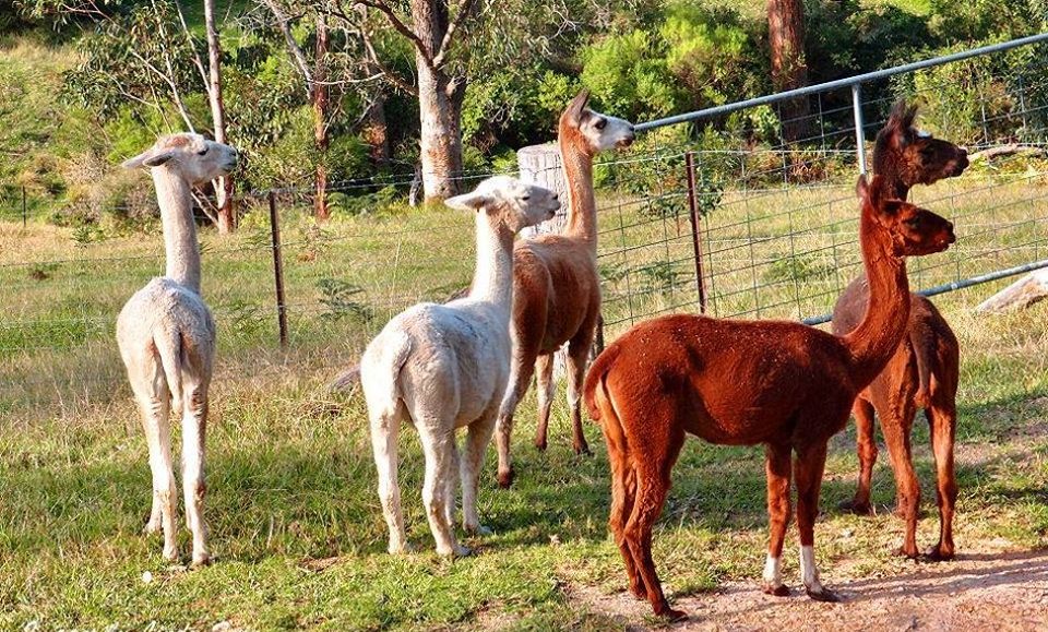
Alpacas at Ballochruin Farm in Balfron Station Road

Alpacas at Ballochruin Farm.


Alpacas at Ballochruin Farm in Balfron Station Road

Alpacas at Ballochruin Farm.


Dumgoyne in the Campsie Fells from Balfron Station Road

Dumgoyne in the Campsie Fells

from 
Balfron Station Road


Kilpatrick Hills from Balfron Station Road

Kilpatrick Hills

from 
Balfron Station Road


Fintry Hills from Meikle Camoquhill Farm

 Fintry Hills

from
Meikle Camoquhill Farm


Public footpath from Wester Camoquhill

 Public footpath

from Wester
Camoquhill 


Route Map of West Highland Way from Carbeth to Drymen

 Public footpath

at Little
Camoquhill 


Public footpath at Little Camoquhill to Balfron

 Public footpath

at Little
Camoquhill to Balfron


Villa in Station Road at Balfron

 Villa in Station Road

 at Balfron


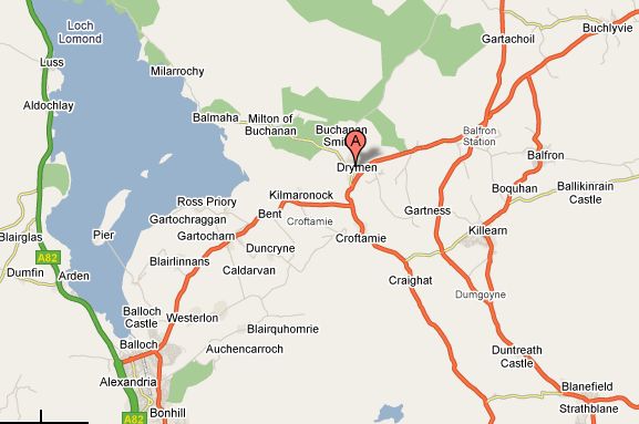
Map of Balfron Area

Map of Balfron Area


Map of Balfron area

Map of Balfron Area


BALFRON CIRCULAR WALK - ROUTE DESCRIPTION:

This walk of about six miles and three hours duration is in and around Balfron.
It is a circular walk and starts from the car park beside the Co-operative building at the top of Buchanan Street in
Balfron.
The view of the hills ahead is impressive as the walk turns right and heads to the bottom of the hill at Dunmore Street and then onto the bowling club.
The walk continues along Buchanan Street and immediately opposite the bowling green is a noteworthy private residence, Auchendarroch, where the aviation pioneers Frank and Harold Barnwell spent their youth. It then passes the sewage works on the left where Robert Dunmore’s Ballindalloch Cotton Mill once dominated life in
Balfron and still going ahead, look out for the name on the right, Printers Row, the home of the cotton printworkers.
The walk leaves the road before the next house, Endrick Cottage, the birthplace of the renowned architect, Alexander ‘Greek’ Thomson, on to initially a car driveway to the house and then a path which goes round the bottom of the garden and along the side of the Endrick Water.
At the end of the path, it climbs a set of steps, turns left to cross Endrick Bridge and then crosses the road to follow the river bank on the other side. Look out for kingfishers and otters which have been spotted on this lovely stretch of the Endrick which sweeps round to a small metal bridge over a burn. If it is not possible to cross the metal bridge and continue along the Endrick river bank to the next road bridge, the walk can follow the burn at the edge of the field and take an alternative route.
Look out for a narrow path on the right after the bend and climb up a short bank to continue round the right hand side of another field and exit on to the A875. lt is a slightly longer route, but has the advantage that, after turning right at the road for a short distance, it enters Jenny Gunn’s Loan, a narrow car track with lovely open views of fields and hills.
It then turns right on to a minor road, passes the entrance to Carbeth Estate and meets the river bank path to cross the road bridge and the Loch Katrine pipe line.
Although out in the country surrounded by beautiful farmland, beware of traffic on this road as the walk proceeds past Ballochruin Farm on the right with its unusual field of alpacas.
It then passes North Ballochruin Farm on the left and at the t-junction ( Station Road ) turns left to reach Meikle Camoquhill Farm.
Follow the sign on the right in front of the farm, 'Public Path Balfron' and turn right onto the minor road to pass Wester Camoquhill Farm on the left.
At the next sign, ‘Public Path Balfron 3/4’, the walk leaves the tarmac on to a grass track and passes through a couple of gates as it winds its way round the edge of a small wood. Beware of grouse shooting in this area,
It then passes Little Camoquhill and the industrial depot on a tarmac surface and after the cottage takes the public path on the right which crosses a footbridge through a small wood to Station Road.
Turning left the walk enters Balfron village, passes some outlying houses before reaching The Clachan and the junction with the A875.
Take in the historical features and buildings in this area, such as the Clachan 0ak, war-memorial and parish church and then return to Buchanan Street and back to the car park.


 Balfron Walk Gallery Photo Gallery :: Balfron Gallery Photo Gallery

<< Back : Bearsden Walks Index :: Next >>


Scotland Index :: Scottish Peaks :: Scotland Walks

Glencoe | Ben Nevis | Knoydart | Isle of Skye | Isle of Arran

The Eastern Highlands | The Central Highlands | The Southern Highlands | The NW Highlands


Adventure Travel : Worldwide Mountaineering : Site Index

fb icon  google+ icon Linkedin icon  twitter


Guide Books & Maps - Scotland:-


West Highland Way: Footprint MapWest Highland Way - Map West Highland Way - Map Western Scotland & the Western Isles OS Road Map Northern Scotland OS Road MapSouthern Scotland OS Road MapGlasgow Popular Hills - Map


Ochils and Campsie Fells

Glasgow Visitor Guide - Colin Baxter Itchy Insider's Guide to Glasgow Glasgow Footprint Pocket Guide Glasgow Insight Pocket Guide Glasgow Guide Pub Companion Glasgow Scotland's Highlands & Islands - Rough Guide Scotland - Rough Guide

Glasgow Insight Pocket GuideCollins Street Map of GlasgowGlasgow: Then & NowThey belonged to Glasgow Phillips Street Atlas of Glasgow & West Central Scotland Glasgow: The Photographic Atlas100 Hillwalks around Glasgow 50 Walks in Glasgow & SW Scotland

Visit Scotland - Touring Guide Scotland: Where to Stay - Hotels & Guest Houses Scotland: Where to Stay - Bed & Breakfast Rough Guide ScotlandScottish Highlands & Islands - Rough Guide Scotland - Lonely PlanetScotland's Highlands & Islands - Lonley Planet Great Glasgow StoriesGlasgow & Surroundings - Insight Guide

West Highland Way: Official GuideWest Highland Way: Rucksac ReadersWest Highland Way: TrailblazerThe West Highland WayWest Highland Way: Footprint MapWest Highland Way - Map West Highland Way - Map West Highland Way Wet Highland Way - Official Guide

Munro Almanac The High Mountains of Britain and Ireland The Munros: Scottish Mountaineering Club The Isle of Skye The Isle of Arran Wilderness Walks Ski Mountaineering in Scotland

More Wilderness Walks 50 Best Routes on Skye and Raasay Skye - W.A.PoucherMagic of the Munros Mountaineering in Scotland and Undiscovered Scotland by W.H.MurrayA Long Walk on the Isle of Skye

Classic Climbs - Central & Southern Highlands The Isle of Arran Lonely Planet, Walking in ScotlandPathfinder Guide: Skye and NW Highlands WalksPathfinder Guide: Fort William and Glen Coe Walks Rambler's Guide: Ben Nevis and Glen Coe50 Best Routes on Skye and Raasay - Chris Townsend


Google Analytics


Google Analytics

extremetracking
 eXTReMe Tracker


extremetracking
Sitelock caingram.com
SiteLock
Sitelock
Sitelock caingram.info
SiteLock
Sitelock