Munros Tables SMC Scottish Highlands Hillwalking Guide

 The Scottish Highlands


Ben Vorlich
The High Mountains of Britain & Ireland Southern Highlands - Map


Photographs of the Munros Ben Vorlich and Stuc a Chroin

in the Southern Highlands of Scotland

Winter Ascent of Ben Vorlich


Ben Vorlich from Meall an t-Seallaidh


Ben Vorlich on ascent from Ardvorlich on Loch Earn

Ben Vorlich ( 3232ft )

on ascent from Ardvorlich

on Loch Earn


Ben Vorlich on ascent of Meall na Fearna

Ben Vorlich

on ascent of Meall na Fearna


Ben Vorlich from Meall na Fearna

Ben Vorlich

from Meall na Fearna


Stuc a Chroin and Ben Vorlich

Stuc a Chroin ( 3199m ) and Ben Vorlich ( 3232ft )

Ben Vorlich lies to the south of Loch Earn

and to the east of Loch Lubnaig


Ben Vorlich and Stuc a Chroin from Creag MacRanaich

Ben Vorlich and Stuc a Chroin

 from Creag MacRanaich


Ben Vorlich and Stuc a Chroin above Loch Lubnaig

Ben Vorlich, Stuc a Chroin

and
Beinn Each ( a Corbett )

above Loch Lubnaig

from Ben Vane


Ben Vorlich and Stuc a Chroin from Ben Ledi

Ben Vorlich, Stuc a Chroin

and
Beinn Each ( a Corbett )

from Ben Ledi


Stuc a Chroin on traverse from Ben Vorlich

Stuc a Chroin

on traverse from Ben Vorlich


Ben Vorlich from Stuc a Chroin

Ben Vorlich

from Stuc a Chroin


Stuc a Chroin from Meall an t-Seallaidh


Stuc a Chroin from Beinn Each


Ben Vorlich and Stuc a Chroin from Creag Uchdag


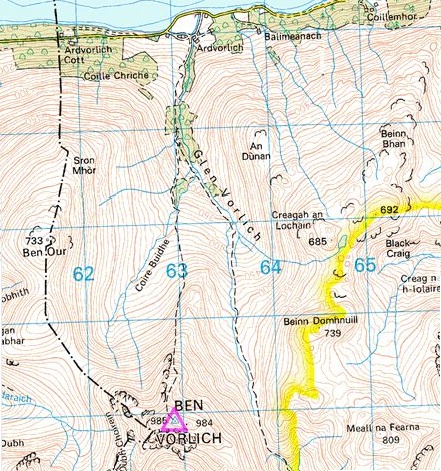
Location Map for Ben Vorlich and Meall na Fearna

Location Map for Ben Vorlich

 and Meall na Fearna


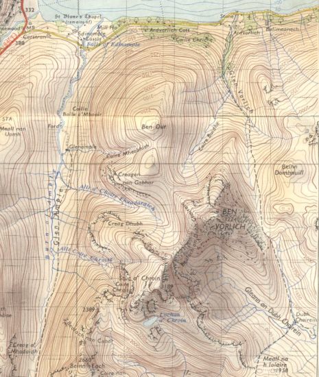
Map of Ben Vorlich, Stuc a Chroin and Beinn Each

Map of Ben Vorlich, Stuc a Chroin

and Beinn Each

( Note: Click here or on map for large format copy )


Route Map for Ben Vorlich

Route Map for Ben Vorlich


BEN VORLICH - ROUTE DESCRIPTION:

Location: Loch Earn, Perthshire
Map=OS Landranger 51, 57 ( GR 629 189 )
Distance: 8miles [ 13km ]
Time: 4hours 15 minutes
Terrain: tracks and paths

Finely featured Ben Vorlich and its broader neighbour Stuc a' Chroin dominate the northern skyline when viewed from the Forth valley. In fact, Vorlich spreads its influence even wider, projecting its pointed summit above the western skyline for much of the A9 through Strathallan.
Both peaks can be climbed together, but they are more enjoyably tackled separately from different directions. Ben Vorlich is the higher of the two, but the ascent from Ardvorlich on Loch Earn to the north is a shorter route than that to Stuc a‘ Chroin from the high ground above Callander to the south. But what Vortich lacks in distance it makes up for in rocky steepness.
To access the route up Vorlich, leave the A84 just south of Lochearnhead and follow the minor road round the south side of Loch Earn to loch side parking at Ardvorlich. Gain the east gate and walk up the track, the start of the right of way to Callander, following the signs to Ben Vorlich. The signposted route goes right then left to a track, which ascends behind the main house to a gate leading to the open hillside. Continue on the track above the Ardvorlich Burn, keeping right where the right of way goes left, until it ends at a bridge over the burn from Coire Buidhe between Ben Vorlich and Ben Our. From here follow the path up the east side of Coire Buidhe, aiming for the north ridge.
The path becomes significantly steeper and rougher as you climb the side of the ridge, then eases off once the broad crest of the ridge is gained. A final steep slope of scree and boulders leads to a grassy slope, the summit ridge and the trig point.
The one metre lower east summit is a short distance along the ridge and Stuc a‘ Chroin is clear to the south.
From the summit follow the path west and then south-west down the ridge leading to the Bealach an Dubh Choirein, the col between Ben Vorlich and Stuc a’ Chroin. At the col drop down slightly into the top of Coire Fhuadaraich to the north west, then traverse to the right to pick up a well-used path crossing the west face of Ben Vortich to the
col between Ben Vorlich and Ben Our at the head of Coire Buidhe. This path continues below the north-west face to join the approach path just below the point where it gains the crest of the north ridge.


Route Map for Ben Vorlich and Stuc a Chroin

Route Map for Ben Vorlich

 and Stuc a Chroin


BEN VORLICH - ROUTE DESCRIPTION 2:

I.ocatlon: Stirlingshire
Map: OS Landranger 51 and 57
Distance: 8 miles( 14km )
Time=5-7 hours
Terrain: serious hillwalk


Ben Vorlich - the Loch Earn one as opposed to the Loch Lomond one - is one of the few Munros where you can sit on the summit
and gaze down the length of the path all the way back to the start — not quite a yellow brick road but certainly a well-groomed highway.
The name Vorlich comes from the Gaelic mur-bhalg, meaning sea-bay, and probably refers to the small bays in Loch Earn.
 Likewise. Ardvorlich, the house at the start of the route, is ard-mhurlaig, the promontory of the sea-bay, and
is the home of the Stewarts of Ardvorlich.
For many years a stone was kept in Ardvorllch House, the clach dhearg or the red stone. which was believed to have miraculous properties.
If you dipped it in a pail of water and moved it three times sun-wise around the pail, the water would then contain
healing powers that could apparently treat sick cattle. So famous was this stone that it attracted people from all around
the area, who came with their own buckets to carry home some of the miraculous water.
There are several ways of reaching Ben Vorlich but the simplest option is to follow the private road south from the east
gate of Ardvorlich House on the south side of Loch Earn.
Follow the track past Ardvorlich House on to the open hillside in Glen Vorlich. Follow the track to the foot of the NNE ridge of Ben Vorlich.
Climb it to the summit.
Follow a line of fence posts down to the Bealach an Dubh Choiretn and follow the steep path which avoids the obvious steep and loose buttress.
From the cairn at the top of the buttress, head south to the summit of Stuc a‘ Chroin.
Return to Glen Vorlich via a high path round the south and east side of Coire Buidhe.
While the ascent of Stuc a’ Chroin from Ben Vorlich is easy enough, it involves scrambling.
From the Bealach an Dubh Choirein you have to climb up the side of some boulder scree to a path that traverses off to the right,
avoiding the steeper sections of the north-east buttress. The path takes a meandering line, zig-zagging between steep sections of rock.
Here and there you have to use your hands. and all the time the steep drop yawns below you. If you find yourself worrying about
descending this route to return to Glen Vorlich then just look a couple of hundred metres to the right, where a much easier descent
path drops down a little corrie. If you are really unhappy on steep ground then this corrie might be your best route of ascent too.
A small cairn lies at the top of the buttress. with a memorial plaque to the founder of the Falkirk Mountaineering Club.


Loch Earn

Loch Earn


Loch Lubnaig

Loch Lubnaig

Loch Lubnaig lies between 
Ben Ledi and Ben Vorlich


 Ben Vorlich Winter Gallery Photo Gallery :: Stuc a'Chroin & Beinn Each Gallery Photo Gallery :: Meall na Fearna Gallery Photo Gallery

<< BackSouthern Highlands : Next >>


Scotland Index :: Scottish Peaks :: Scotland Walks

Isle of Skye :: Isle of Arran

Knoydart :: Glencoe :: Ben Nevis :: NW Highlands :: Eastern Highlands :: Central Highlands


Worldwide Mountaineering :: Adventure Travel :: Site Index

fb icon  google+ icon Linkedin icon  twitter


Guide Books & Maps - Scotland:-


Arrochar Alps - Map Glasgow Popular Hills - Map West Highland Way - Map Loch Lomond North - Tyndrum, Crianlarich, Arrochar - OS Explorer Map Loch Lomond and Inverary OS Landranger Map

Isle of Arran OS Explorer Map Isle of Arran OS Landranger Map Arran - Official Tourist MapIona & Mull MapWestern Scotland & the Western Isles OS Road Map Northern Scotland OS Road MapSouthern Scotland OS Road Map


The High Mountains of Britain & Ireland  Munros Tables SMC  The Munros - Scotland's Highest Mountains  Scotland - Lonely Planet  NW Highlands - SMC Guide  Exploring the Far NW of Scotland  Guide to Walks in NW Highlands

Walking in Scotland - Lonely Planet Mountain: Exploring Britain's High Places  National 3 Peaks Walk Scottish Highlands Hillwalking Guide The Scottish Islands Bouldering in Scotland

Central Highlands: Six Long Distance Walks West Highland Way: Official GuideWest Highland Way: Rucksac ReadersWest Highland Way: TrailblazerThe West Highland WayWest Highland Way: Footprint MapWest Highland Way - Map West Highland Way - Map 100 Hillwalks around Glasgow

Pathfinder Guide: Fort William and Glen Coe Walks Rambler's Guide: Ben Nevis and Glen CoeGlencoe Rock & Ice Climbing The Munros: Scottish Mountaineering Club The Munros and Tops The Corbetts - SMC Munros & Corbetts Chart The High Mountains of Britain and Ireland Munro Almanac

The Munros - Scotland's highest mountains Call of the Corbetts Magic of the Munros Hamish's Mountain WalkThe Munros in WinterMy Scotland by Hamish MacInnes

Scottish Mountains - 50 Classic Routes50 More Routes on Scottish Mountains The High Mountains of Britain and Ireland Scotlands 100 Best Walks Scottish Mountains - 100 Best RoutesBig Walks of Great Britain Classic Walks in Britain & Ireland

Scottish Hill & Mountain Names Classic Mountain Scrambles in Scotland Classic Climbs - Central & Southern Highlands Mountaineering in Scotland and Undiscovered Scotland by W.H.MurrayMore Wilderness Walks Wilderness Walks Wilderness Walks 2 - Video Ski Mountaineering in Scotland

Ski Touring in ScotlandScrambles in Lochaber Rock Climbing in Scotland Rock Climbing SkillsThe FACE: Six Great Climbing Adventures Ben Nevis: Rock & Ice ClimbsGreat Snow & Ice Climbs of the British Isles100 Best Routes on Scottish Mountains One Man's Mountains - Tom Patey

A Mountaineer's Tale - W.H.MurrayDougal Haston: Philosophy of RiskThe Glens of Rannoch Southern Highlands - MapNorthern Highlands Central Highlands West Highlands Central Highlands SMCNW Highlands SMC

Scotland - Lonely PlanetScotland's Highlands & Islands - Lonley Planet Scotland's Highlands & Islands - Rough Guide Highlands & Islands of Scotland - Hidden Places Rough Guide ScotlandScottish Highlands & Islands - Rough Guide Rough Guide: Scotland Lonely Planet, Walking in ScotlandLonely Planet - Walking in Britain

50 Walks in the Scottish Highlands & Islands 100 Walks in ScotlandVisit Scotland - Touring Guide Scotland: Where to Stay - Hotels & Guest Houses Scotland: Where to Stay - Bed & Breakfast Hillwalker: The MunrosHillwalker: The Corbetts

Weather for Hillwakers & Climbers Mountain Weather Guide to the Weather Weather: Collins Gem Hillwalking Handbook for Mountain Leaders Hillwalkers Manual Hillwalkers Guide to Mountaineering First Aid on Mountains


Google Analytics


Google Analytics

extremetracking
 eXTReMe Tracker


extremetracking
Sitelock caingram.com
SiteLock
Sitelock
Sitelock caingram.info
SiteLock
Sitelock