

Glasgow Guide Glasgow Visitor Guide - Colin Baxter

Paisley

Robertson Park
on
Glennifer Braes
Scotland's Highlands & Islands - Rough Guide Scotland - Rough Guide


Photographs of Robertson Park area

 of Glennifer Braes
Country Park

on the southern outskirts of
Paisley

 in the West of Scotland

Map of Robertson Park area of Gleniffer Braes Country Park on the southern outskirts of Paisley

Map of Robertson Park area

 of Gleniffer Braes
Country Park

on the southern outskirts of Paisley

Gleniffer Braes is an upland park of moorland

 with woods and hill farming areas.

Attractions include the wildlife

 and waymarked trails.


View from the "Car Park in the Sky" in Robertson Park area of Gleniffer Braes Country Park

View from the "Car Park in the Sky"

 in Robertson Park area

 of
Gleniffer Braes Country Park


View from the "Car Park in the Sky" in Robertson Park area of Gleniffer Braes Country Park

View from the "Car Park in the Sky"

 in Robertson Park area

 of
Gleniffer Braes Country Park

Ben Lomond on skyline


Sign in Robertson Park area

Sign in Robertson Park area 


Trail in Robertson Park area

Trail in Robertson Park


Stanely Reservoir in Paisley from Robertson Park

Stanely Reservoir in Paisley

from Robertson Park 


Trig Point in Robertson Park

Trig Point in Robertson Park


Viewpoint in Robertson Park

Viewpoint in Robertson Park


Lone tree on Gleniffer Braes

Lone tree on Gleniffer Braes


Highland Cattle in Gleniffer Braes Country Park

Highland Cattle

 in Gleniffer Braes Country Park

The Cattle are used in the park
to control the vegetation,
 preserve biodiversity
and retain open spaces.


Paisley Golf Course alongside Gleniffer Braes Country Park

Paisley Golf Course

 alongside Gleniffer Braes Country Park


Stanely Reservoir in Paisley from Robertson Park

Stanely Reservoir in Paisley

from Robertson Park


Cattle in Gleniffer Braes Country Park

Cattle

 in Gleniffer Braes Country Park


Viewpoint at Robertson Park

Viewpoint

 at Robertson Park


Stanely Castle in Stanely Reservoir

Stanely Castle in Stanely Reservoir

An L-shaped tower house
of four storeys
probably built in the early 15th century
 on an island within a marsh.

Since 1837 it has been partially submerged
 by the reservoir
.


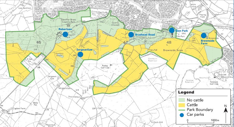
Map of Gleniffer Braes Country Park on the southern outskirts of Paisley

Map of Gleniffer Braes Country Park

on the southern outskirts of Paisley


Map of Gleniffer Braes Country Park


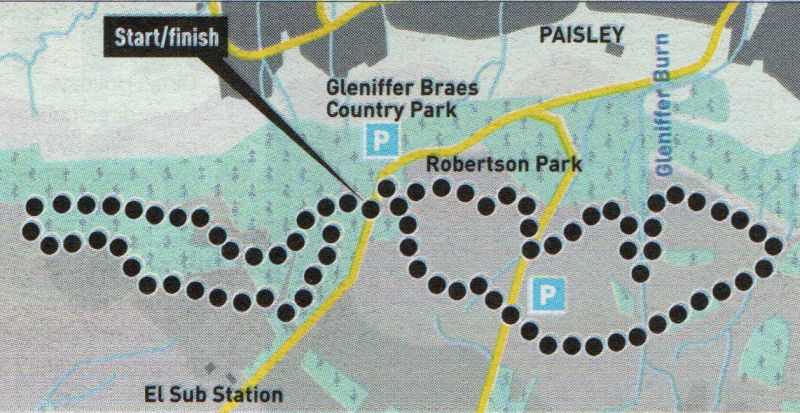
Route Map for Robertson Park in Paisley

Route Map for Robertson Park


ROBERTSON PARK WALK - ROUTE DESCRIPTION:


Location: Paisley
Map: OS Landranger 64
Distance: 4.25 miles [ 7km ]
Time: 2 hours 20 minutes
Terrain: paths, some signposts

Paisley's "car park in the sky” at Robertson Park is the starting point for this fine circuit of the two western sections of the Gleniffer Braes above the town. In his classic Rambles Round Glasgow (1854), Hugh MacDonald praised the view from here as the fairest in Scotland. While MacDonald's view has changed somewhat in the past 150 years, it remains a fine prospect north over the Clyde valley to the Kilpatrick Hills and Ben Lomond.
Leave Robertson car park and cross Gleniffer Road on to a path signposted Brandy Burn. Follow the main path round with good views over to Ben Lomond, then left towards conifer plantations and a firebreak. Turn right at the junction and continue to clear the trees, then go left below pylon wires to gain the trig point at point 218m and open views north. Facing
Ben Lomond, descend diagonally left to gain a lower path and follow it below the woodland edge veering right where the path divides, to descend below the plantation past old concrete marker blocks. Go through a tongue of conifers and drop down right to gain a well-worn path that leads to a kissing gate at the edge of Bardrain Wood. Turn left and ascend to the conifer boundary and follow it round towards the electricity substation.
Follow the path round the perimeter fence past two gates and into woodland. Pass the firebreak and on to where the fence turns sharp right. Turn left here and follow a path through the woodland, right, then left, to a junction. Go left, climb to a high point with a bench and fine views, then follow the path down right and cross the road back to Robertson car park.
Turn right in the car park and up through an old pedestrian gate into open meadow, keeping right where the grassy paths divide, then swinging round left past a solitary tree to meet a track leading to the ear park on Sergeant Law Road. Pass through a metal kissing gate and follow the boundary of Paisley Golf Club down past the clubhouse to the crest of the Gleniffer Braes, where a large wooden post with horseshoes indicates a path heading off to the left. Contour the braes west to gain a tarmac path beside Gleniffer Gorge. Turn left and follow the tarmac and earth path up and over the gorge then back down the other side, before heading west over the braes to reach Sergeant Law Road again. Cross over and go right on a good path signposted Tannahill Walkway, Robertson Park and Brandy Burn Way, which leads back to the Robertson car park.


Robertson Park Gallery Photo Gallery :: Gleniffer Braes Gallery Photo Gallery

<< Back : Glasgow Parks : Next >>


Scotland Index :: Scotland Walks

Glencoe | Ben Nevis | Knoydart | Isle of Skye | Isle of Arran | The West Highland Way

The Eastern Highlands | The Central Highlands | The Southern Highlands | The NW Highlands


Adventure Travel : Worldwide Mountaineering : Site Index

fb icon  google+ icon  Linkedin icon  twitter


Guide Books & Maps - Scotland:-


Western Scotland & the Western Isles OS Road Map Northern Scotland OS Road MapSouthern Scotland OS Road MapGlasgow Popular Hills - Map


Glasgow - A Portrait  Wee Book of Glasgow  Glasgow from the Air  Glasgow - No Mean City  Lost Glasgow  Glasgow - The Real Gorbals Story    

Glasgow Visitor Guide - Colin Baxter Itchy Insider's Guide to Glasgow Glasgow Footprint Pocket Guide Glasgow Insight Pocket Guide Glasgow Guide Pub Companion Glasgow Scotland's Highlands & Islands - Rough Guide Scotland - Rough Guide

Glasgow Insight Pocket GuideCollins Street Map of GlasgowGlasgow: Then & NowThey belonged to Glasgow Phillips Street Atlas of Glasgow & West Central Scotland Glasgow: The Photographic Atlas100 Hillwalks around Glasgow 50 Walks in Glasgow & SW Scotland

Visit Scotland - Touring Guide Scotland: Where to Stay - Hotels & Guest Houses Scotland: Where to Stay - Bed & Breakfast Rough Guide ScotlandScottish Highlands & Islands - Rough Guide Scotland - Lonely PlanetScotland's Highlands & Islands - Lonley Planet Great Glasgow StoriesGlasgow & Surroundings - Insight Guide

West Highland Way: Official GuideWest Highland Way: Rucksac ReadersWest Highland Way: TrailblazerThe West Highland WayWest Highland Way: Footprint MapWest Highland Way - Map West Highland Way - Map West Highland Way Wet Highland Way - Official Guide

Munro Almanac The High Mountains of Britain and Ireland The Munros: Scottish Mountaineering Club The Isle of Skye The Isle of Arran Wilderness Walks Ski Mountaineering in Scotland

More Wilderness Walks 50 Best Routes on Skye and Raasay Skye - W.A.PoucherMagic of the Munros Mountaineering in Scotland and Undiscovered Scotland by W.H.MurrayA Long Walk on the Isle of Skye

Classic Climbs - Central & Southern Highlands The Isle of Arran Lonely Planet, Walking in ScotlandPathfinder Guide: Skye and NW Highlands WalksPathfinder Guide: Fort William and Glen Coe Walks Rambler's Guide: Ben Nevis and Glen Coe50 Best Routes on Skye and Raasay - Chris Townsend


Google Analytics


Google Analytics

extremetracking
 eXTReMe Tracker


extremetracking
Sitelock caingram.com
SiteLock
Sitelock
Sitelock caingram.info
SiteLock
Sitelock