West Highland Way: Trailblazer Ochils and Campsie Fells

 Bearsden Walks

 Kippen Circular
West Highland Way - Map West Highland Way: Footprint Map
 

Photos of a circular walk around the village of Kippen:-

Arngomery House, Broich Mill Cottage, Broich Burn, Cauldhame,

 Southern Highlands, Ochil Hills, Gargunnock Hills


Gillespie Hall in Kippen Village

Gillespie Hall in Kippen Village

Kippen is a small village

approximately 10 miles ( 16km ) to the west of  
Stirling.


It lies between the 
Gargunnock Hills ,

the Fintry Hills to the South

and the
Strath of the River Forth to the North.


Rennie's Loan from Kippen Village

Rennie's Loan from Kippen Village


Ben Lomond from Rennie's Loan

Ben Lomond from Rennie's Loan


Ben Lomond on ascent to Spout of Ballochleam

Rennie's Loan

on approach to the B8037

access road to Kippen


Grounds of Arngomery House

Grounds of Arngomery House


Arngomery House

Arngomery House

 - a Victorian mansion house


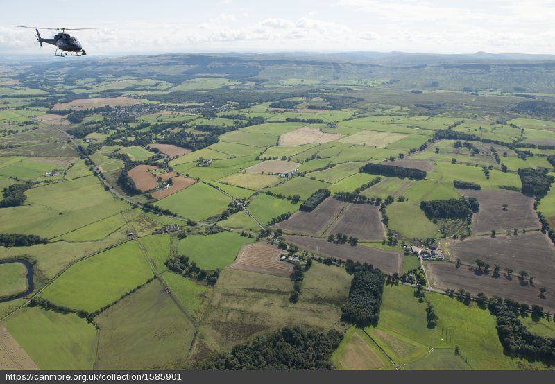
Aerial view of Arngomery House

Aerial view of Arngomery House


The Stables Building of Arngomery House

 The Stables Building of Arngomery House


Arngomery House and Ben Lomond

Arngomery House and Ben Lomond


Broich Mill Cottage

Broich Mill Cottage ( b1801 )


The Broich Burn

The Broich Burn


Southern Highlands across the Strath of Forth from the road into Cauldhame

Southern Highlands

across the Strath of Forth

 from the road into Cauldhame


Cottages in Cauldhame

Cottages in Cauldhame


Public Footpath from Cauldhame to Burnside Woodland

Public Footpath

 from Cauldhame to Burnside Woodland


Road from Riggethill through Burnside Woodlands

Road from Riggethill

through Burnside Woodlands


Gargunnock Hills from above Gargunnock Hills from above Burnside Woodlands

Gargunnock Hills

from above Burnside Woodlands


Ochil Hills from above Burnside Woodlands

Ochil Hills

from above Burnside Woodlands


Duck Pond in Burnside Woodlands above Kippen

Duck Pond in Burnside Woodlands

 above Kippen


School in Kippen

School in Kippen


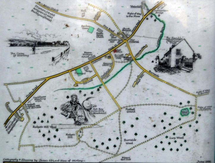
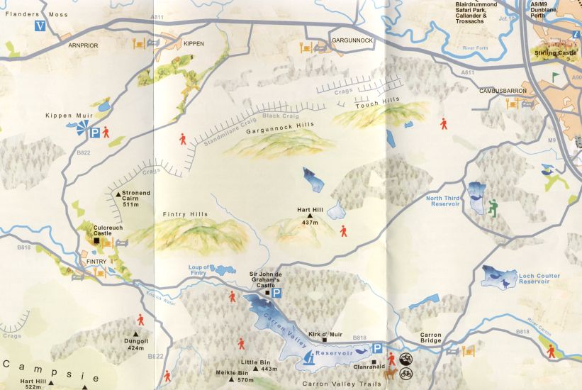
Map of Kippen Village

Map of Kippen Village

( Note: click here or on above for large format copy )


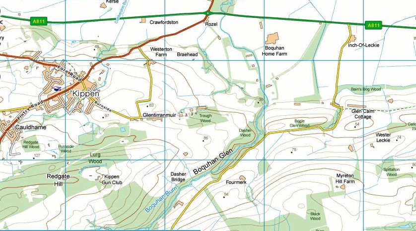
Map of Kippen area


Map of Kippen area

Map of Kippen area


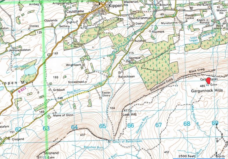
Map of the Gargunnock Hills

Map of the Gargunnock Hills


KIPPEN CIRCULAR WALK - ROUTE DESCRIPTION:


This circular walk is from Kippen to Arngomery House and Broich Mill.
This is an easy route and suitable for walkers of all ages and most levels of fitness. It is of 2.5 miles mostly on firm ground, although there are two muddy sections, so wear weatherproof boots and it is a good idea to carry a stick.
Kippen seems to have adrier climate than Milngavie, perhaps because it is in the lee of the Gargunnock Hills and the Campsie Fells a little further away to the south west. The village lies on the lower flanks of the Gargunnocks.
When you look east along the Forth valley towards Stirling you are almost guaranteed to see blue skies even if over your shoulder to the west the view is obscured by low clouds.
Walk north from Kippen Cross down Rennie's Loan at the top of which is the old smiddy. The lane soon gives way to a soft grassy track which used to be an old drovers' road. It leads gently downhill, past several large back gardens. The track goes through an open double gate and swings
lefi. just before the main A811 to Stirling.
Now you are on a metalled lane walking past a farm on your right. This lane emerges onto the main access road from the A811 to Kippen.
Turn left and walk along the pavement for 150 yards to a Public Footpath sign on the right hand side of the road.
There is also a sign here for Arngomery House. Take this tarred lane, the access for the big house, and follow it round to the right until you are above the house and its converted stables. Here on the left you will see a conspicuous white footpath sign to Broich.
Go through a kissing gate and follow the path around the right hand side of the grassy pasture, keeping close to the fence. This leads to another gate. The path keeps straight on following the fence. Here the ground is very soft and wet. If you keep to the left of the path you will find the ground is firmer. This wet stretch is about 300 yards long. Then you come to another gate. Beyond it the ground is firm and the path ascends through a narrow belt of deciduous trees.
Now to Broich Mill Cottage. Above its door is a block of red sandstone inscribed with the original date of construction (1801) and the words “Re-stored 1928 by EL Ewing“. The next cottage also has a memorial to the same restorer who restored it in 1933. Above the cottages there is a lovely picnic spot by the banks of the burn presumably called the Broich.
The path then becomes a track and joins a minor road. When you arrive here turn left, and here you will enjoy wonderful wide views to the east and north across the Forth Valley. This is one of the main reasons people come up to walk in this beautiful area of Scotland.
This minor road soon joins the Kippen to Fintry road and has a pavement to ensure that you can walk safely the short distance back to Kippen's main street.


   Kippen Circular Gallery Photo Gallery :: Kippen Gallery Photo Gallery :: Gargunnock Hills Gallery Photo Gallery

<< Back : Bearsden Walks Index : Next >>


Scotland Index :: Scottish Peaks :: Scotland Walks

Glencoe | Ben Nevis | Knoydart | Isle of Skye | Isle of Arran

The Eastern Highlands | The Central Highlands | The Southern Highlands | The NW Highlands


Adventure Travel : Worldwide Mountaineering : Site Index

fb icon  google+ icon  Linkedin icon  twitter


Guide Books & Maps - Scotland:-


West Highland Way: Footprint MapWest Highland Way - Map West Highland Way - Map Western Scotland & the Western Isles OS Road Map Northern Scotland OS Road Map Southern Scotland OS Road Map Glasgow Popular Hills - Map


Ochils and Campsie Fells

Glasgow Visitor Guide - Colin Baxter Itchy Insider's Guide to Glasgow Glasgow Footprint Pocket Guide Glasgow Insight Pocket Guide Glasgow Guide Pub Companion Glasgow Scotland's Highlands & Islands - Rough Guide Scotland - Rough Guide

Glasgow Insight Pocket GuideCollins Street Map of GlasgowGlasgow: Then & NowThey belonged to Glasgow Phillips Street Atlas of Glasgow & West Central Scotland Glasgow: The Photographic Atlas100 Hillwalks around Glasgow 50 Walks in Glasgow & SW Scotland

Visit Scotland - Touring Guide Scotland: Where to Stay - Hotels & Guest Houses Scotland: Where to Stay - Bed & Breakfast Rough Guide ScotlandScottish Highlands & Islands - Rough Guide Scotland - Lonely PlanetScotland's Highlands & Islands - Lonley Planet Great Glasgow StoriesGlasgow & Surroundings - Insight Guide

West Highland Way: Official GuideWest Highland Way: Rucksac ReadersWest Highland Way: TrailblazerThe West Highland WayWest Highland Way: Footprint MapWest Highland Way - Map West Highland Way - Map West Highland Way Wet Highland Way - Official Guide

Munro Almanac The High Mountains of Britain and Ireland The Munros: Scottish Mountaineering Club The Isle of Skye The Isle of Arran Wilderness Walks Ski Mountaineering in Scotland

More Wilderness Walks 50 Best Routes on Skye and Raasay Skye - W.A.PoucherMagic of the Munros Mountaineering in Scotland and Undiscovered Scotland by W.H.MurrayA Long Walk on the Isle of Skye

Classic Climbs - Central & Southern Highlands The Isle of Arran Lonely Planet, Walking in ScotlandPathfinder Guide: Skye and NW Highlands WalksPathfinder Guide: Fort William and Glen Coe Walks Rambler's Guide: Ben Nevis and Glen Coe50 Best Routes on Skye and Raasay - Chris Townsend


Google Analytics


Google Analytics

extremetracking
 eXTReMe Tracker


extremetracking
Sitelock caingram.com
SiteLock
Sitelock
Sitelock caingram.info
SiteLock
Sitelock